WikiProject Burundi
| |
| latitude: -3.4, longitude: 30.0 |
| Browse map of Burundi 3°24′00.00″ S, 30°00′00.00″ E |
| Edit map |
|
External links:
|
| Use this template for your city |
Burundi is a Country in Africa at latitude 3°24′00.00″ South, longitude 30°00′00.00″ East.
Contents
Map of Burundi
Burundi data
- Access OSM data for Burundi in GIS formats through the HOT Exports Tools - Burundi
- HOT Exports - Bujumbura
- The OSM map of Burundi for GPS Garmin devices. Please find here how to install this map on the GPS Garmin's micro SD card.
- Common and Fundamental Operational Datasets on the site of OCHA.
- Africover ([1]) - has granted us (Development Seed ([2]) - permission to upload their base layers - roads, rivers, rails, admin boundaries. Dev Seed has uploaded the road shapefile. With that done, Dev Seed has concluded its import operations in Burundi.
Projects in Burundi
This is a list of projects in Burundi
- Boundaries of Burundi
- EUROSHA project
- Highways of Burundi
State of the map
Relatively little mapping has been done in Burundi by now, mainly because of missing aerial imagery of the great part of the country and lack of local contributors. Lately there has been registered great progress in mapping of Bujumbura, partly due to the EUROSHA project, which has been running there since October.
HOT in Burundi
HOT is conducting a mapping project in Burundi since mid-October 2012 as part of the EUROSHA project together with France Volontaire. The initial focus is on baseline mapping of Bujumbura and the regions in which the needs are most crucial. All these activities are meant to support the growth of a local OSM group in Burundi and the growth of the OSM project.
Events
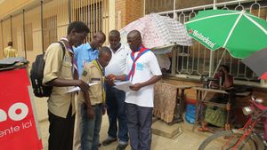
- Mapping party with EUROSHA BURUNDI Project with Scouts and Guides (Bujumbura): 11-24-2012
- Mapping party with EUROSHA BURUNDI Project with Scouts and Guides (Bujumbura): 12-15-2012
- Formation on Open Street Map tools with EUROSHA BURUNDI Project with AJDI (Association des Jeunes pour la Démocratisation de l'Informatique): Starting from 12-10-2012
What we are working on
Baseline mapping of Bujumbura
Using satellite imagery and field surveys, the international team of EUROSHA volunteers is trying to improve the map of Bujumbura, which is not really complete for now. Although we do our best to make some progress at this point, this task remains unfinished due to other activities.
Formation on OSM tools
- First training on using OpenStreetMap tools held by EUROSHA project has started from 12-10-2012 with motivated group of IT students of AJDI (Association des Jeunes pour la Démocratisation de l'Informatique). Five mid-day technical sessions have been held, including one mapping party with this group. The training is previewed to be concluded in January by evaluation. The plan is to follow the group and involve it to our next activities.
- From January on, the OSM training with Scouts and Guides is planned to be done on the same basis as the training we are working on with AJDI.
Useful resources
Aerial Imagery
Aerial Imagery can be a very useful tool in mapping. However, all data derived from aerial imagery should be verified in the field. Great care should be taken, that aerial images are aligned properly with the coordinate system in OSM. The best way is to align the images with ways in OSM that are derived from or verified by GPS survey in the field. It would be very helpful when the source of the data is easily identified, for instance by using [source=GPS] or [source=Yahoo] etc.
Currently, there is a project called Better maps for Burundi run by Japan International Cooperation Agency (JICA) which consists in the creation of the new aerial imagery of Burundi.
Yahoo satellite imagery
Yahoo! imagery is no longer available since 13 September 2011. Yahoo! Aerial Imagery covered the area around Bujumbura. Map.
Bing satellite imagery
Bing coverage for Burundi is available in high resolution in area of Bujumbura Marie, Bujumbura Rural and Gitega. The imagery comes from 2010.
External Links
- Quality control with Osmose - Quality control with Osmose
