

Displaced populations maintain sense of community along Route National 1


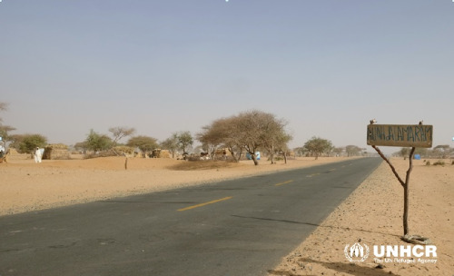


Entire villages in the Diffa region have been deserted following increased attacks by insurgent groups in the region since August 2015. This is most prevalent along the Komadougou River which serves as a natural boundary between Niger and the Northern states or Nigeria. During the first displacements in the region, the majority of the displaced people were welcomed into the homes of the host communities in towns and villages. However with the increase in internal movements following increased violence in the region in 2015, the host community can no longer help all of those in need. Instead entire villages are deserting their homes and fleeing to areas where they feel more secure. The majority of these people are choosing to settle along the main national road in the region, Route National 1 (for more information see: http://unhcrniger.tumblr.com/post/136596283354/route-nationale-1-goudron-des-d%C3%A9plac%C3%A9s).
The humanitarian community is struggling to respond to the urgent needs of the newly displaced. However, the displaced are clinging to their sense of community and identity, despite the hardships they are facing. All along Route National 1 handmade signs can be seen declaring the names of the villages where the various communities have come from. This makes it easier for the humanitarian community to identify the people and to provide the assistance they need, while it also maintains a sense of community and belonging for those who are displaced. The slideshow above shows a small sample of the signs declaring the names of the villages of the displaced communities. It is estimated that there are currently between 50,000 and 70,000 people living along the road with the numbers increasing day by day.